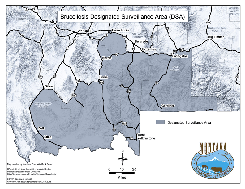
32.3.433 DESIGNATED SURVEILLANCE AREA
(1) The designated surveillance area (DSA) of Montana is described as:Ā
(a) Park County ¢ south of Interstate 90;
(b) Gallatin County ¢ south of Interstate 90 from the Park-Gallatin County line to U.S. Highway 191 at Bozeman, then south of U.S. Highway 191 to Highway 84, then south of Highway 84 to Churchill Road, then west of Churchill Road to Interstate 90 at Manhattan, then all other areas in Gallatin County south of Interstate 90, but west of Churchill Road;
(c) Madison County ¢ east of Highway 287 from its northern crossing of the Gallatin-Madison County line to Ennis, then south of State Highway 287 from Ennis to Alder, then east of State Rd. 357 (Upper Ruby Road) to Sweetwater Road, then south of Sweetwater Road to the Madison-Beaverhead County line; and
(d) Beaverhead County ¢ from Madison-Beaverhead County line, south of Sweetwater Road to East Bench Road near Dillon, then south of East Canal Bench Road to White Lane, then south of White Lane to Blacktail Road, then south of Blacktail Road to Highway 91, then west of Highway 91 to Interstate 15 business loop, then south of Interstate 15 business loop to Interstate 15, then east of Interstate 15, to Big Sheep Road at Dell, then east of Big Sheep Road to Deadwood Gulch Road (BLM Road 1869), then east of Deadwood Gulch Road to Forest Road 8273, then east of Forest Road 8273 to Forest Road 1033, then east of Forest Road 1033 to the West Fork of Little Sheep Creek, then east of the West Fork of Little Sheep Creek to the headwaters north of Round Timber Spring to the Montana/Idaho border.
(2) A map of the designated surveillance area follows:
Ā
History: 81-2-102, 81-2-103, 81-2-104, MCA; IMP, 81-2-101, 81-2-102, 81-2-103, 81-2-104, MCA; NEW, 2011 MAR p. 147, Eff. 2/11/11; AMD, 2011 MAR p. 1551, Eff. 8/12/11; AMD, 2012 MAR p. 1258, Eff. 6/22/12; AMD, 2014 MAR p. 2141, Eff. 9/19/14; AMD, 2018 MAR p. 1960, Eff. 10/6/18.